| Back to Back Issues Page |
 |
|
Kimberley and NT News: Roads and parks updates, more roads being sealed? May 31, 2018 |
30 May 2018, Issue #067 Please do not reply to this message. To unsubscribe or change your address please use the links at the bottom of this message. To contact me please use the contact page. To sign up for this newsletter and receive the free Kimberley Pocket Guide go here. In this issue:
Hi Happy post-GDPR week! If you don't know what that means, consider yourself lucky. The new data protection regulations that came into force last Friday have kept me (and most every other website owner on the planet) busier than I've been since I can't remember when. And I'm still not done with it... But, somehow I did manage to put a newsletter together, so let's get to that! Roads/Parks Updates One day after I sent out the last newsletter I received the information that, contrary to what I had been telling you, the Wyndham Shire did not expect the Kalumburu Road to open until May 25. Grrr. But then they were able to open it on May 21 already, hooray! Which means the info I had given you in the newsletter ended up being correct after all and I could have saved myself the little updates I published on the What's New page. Anyway, the Kalumburu Road was opened all the way on May 21, for high clearance 4WD only, and extreme caution is advised. Having said that, tourists have been arriving in Kalumburu towing boats and large offroad vans. Most of the road is freshly graded and in reasonable condition. Of course, there are a few rougher parts. The only part that's still really rough is the last stretch, a good 30km, before you reach Kalumburu. That part is very rocky and you can't grade rocks. It isn't a problem though, just take it easy. And that's all I have for road updates in the Kimberley. The Kalumburu Road was the last main road that everyone had been waiting for to open. What I wrote in the last newsletter still applies: Not all side roads and access track to lesser know gorges and lower lying areas are open yet. So if you plan to visit any of those, contact the respective stations or parks or look at their online reports to get the latest details. (Contact info and links, of course, in the appendix of Destination Kimberley.) There is one little park update, and I should have reported that in the last newsletter already, but forgot to include it. Sorry!! Both the Windjana Gorge and the Silent Grove (Bell Gorge) campground now offer online booking. This is handy if you travel during peak season AND know the exact date you'll be there. If you plan to travel now or are winging it anyway and taking it as it comes, just rock up as before. During peak season do make sure that you get there early in the day. Both campgrounds can get very full during peak season and sites are allocated on a first come, first served basis. Book a site at Silent Grove here. Book a site at Windjana Gorge here. The price is the same as in the other Kimberley national parks: $13 per night per person. I want to point you once more at my What's New page. When I realised that I had forgotten to include that info, I published a note about it there. I can not always send out a newsletter immediately when I get a new piece of information (or realise I forgot to include an older one), so bookmarking and checking that page before you leave is probably a good idea. (Online booking at those campgrounds is not at all critical or required that early in the season. If it was critical I would have sent an extra newsletter.) What is new at the main NT parks? In Kakadu National Park Maguk and the old Jim Jim Road opened as predicted but the Koolpin Gorge open date has been pushed back to mid June. The forecast open dates for the Jim Jim area have also changed: Jim Jim Falls is expected to open early June, Twin Falls apparently not until mid July. Beyond that what I said in the last newsletter still applies. For Litchfield National Park my personal prediction that the Reynolds River Track and southern areas will NOT be open by the end of May (as the official info predicted) turned out to be correct: They now say those parts will open some time in June. Walker Creek is now open, the Tabletop Track is still closed. Wangi Falls is still closed for swimming as are the Lower Cascades. At Nitmiluk (Katherine Gorge) all the walks are open now as is all swimming except in the first gorge. Boat tours operate on the first and second gorge, still no canoeing. You can find more details for those parks as well as information for all the other parks in the Darwin and Katherine region, and of course info for the Kimberley, in the respective online reports. They are all listed and linked in the appendix of Destination Kimberley and Destination Top End. If you need more information than the reports offer, you also find phone numbers for each park or station, either in the report itself, in the appendix, or in the relevant section of your guide book. Bushwalking In Mitchell Falls National Park The changes in the management and permit system on the Mitchell Plateau are still causing confusion. One reader asked: "In your last e-news you advised how to purchase the Ngauwudu Road pass on-line. When purchasing the pass, a statement advises that no "bush walking corridors" are open until July 1st. Does this mean that you cannot walk from the Mitchells Falls campground to the actual Falls? I have tried calling the Wunambal Gaambera contact number but they appear not to be answering or returning calls. It seems a bit odd that you can't walk to the Falls in high season." The "bush walking corridors" that you may read about when you purchase your Ngauwudu Road Zone Permit refers to permits for overnight bushwalks that people do up there. We are talking self supported, multi day wilderness walks. You would not be able to do any walking like that before July 1. But this has nothing to do with maintained and sign posted national park walking trails. Rest assured that you are certainly allowed to walk to the Mitchell Falls! Cape Leveque Road Being Sealed One reader asked: "We are travelling to Cape Leveque at the end of July and I was hoping to find out how much of the road is now sealed. I tried looking on main roads and other websites and am unable to find any answers that are recent." The northern half of the Cape Leveque Road, everything north of Beagle Bay, has been sealed for many years now. So this question refers to the remaining 90 km on the southern end. You may have heard that work has started on sealing those parts, too. At this stage the crews are still doing mostly pre-construction work, like for example putting in water reservoirs. But as the season progresses you will start to see the actual road works. Do not expect much to happen until July though. This project is expected to take three to four years to complete! For this season any fresh bitumen will probably save you as much time as the road works will cost you. I remember chatting about the road with one of the local women at one of the communities up there. This was many years ago, after the northern parts had been sealed. She was laughing and saying that it was perfect now. They had wanted good roads up north so they can more comfortably and easily visit each other at the communities, but they didn't want a better connection to the outside world. Well, in the end money and "progress" always win. Once that work is completed, it will change the character of the whole peninsula. If you are still only thinking about going, stop thinking and just do it. Do it soon! Red Centre Way Sealed? The question whether the Red Centre Way is indeed sealed now has appeared in my inbox several times already. There appears to be some confusion about the road(s) between Kings Canyon and the West MacDonnell National Park/Hermannsburg/Alice Springs and people are getting conflicting information. So let's see if I can clear that up... The Red Centre Way is a popular loop drive that lets you visit "the big three", namely Uluru, Kata Tjuta and Watarrka (Kings Canyon), without much backtracking. Or rather, the "Outer Loop" version of the Red Centre Way lets you do that. The "Inner Loop" is a much abbreviated round drive, connecting Hermannsburg and the Larapinta Drive with the Namatjira Drive and West MacDonnell NP. It skips the Uluru Kata Tjuta and Watarrka national parks. Here, I made a little map for you that shows both. (Excuse my mapping skills.) Red and purple: Outer Loop Red and green: Inner Loop 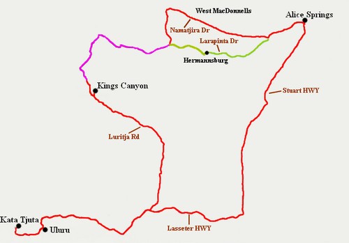
People keep contacting me because they heard it is possible to return on sealed roads from Kings Canyon to Alice Springs, without backtracking, after visiting Uluru and Kata Tjuta. No, this is not possible! You can not drive from Kings Canyon to Hermannsburg and the West MacDonnells (and on to Alice Springs) on a sealed road. What has been fully sealed is the Inner Loop! The 43 km west of Hermannsburg, that is the part that was recently sealed. But the connection from Kings Canyon to that Inner Loop, the part that is shown purple in my map, is still unsealed. If you want to visit Uluru and Kings Canyon and then return to Alice Springs on a sealed road, you will have to backtrack the whole way on the Lasseter and Stuart highways. The recent sealing of the Inner Loop received a lot of publicity. And because both those drives are called "loops", and both are also referred to as the "Red Centre Way", and because they overlap in parts, people end up confusing the two. At least that is my theory on how my readers received the conflicting information they mentioned. Hope that clarifies! If you want to visit the Alice Springs region, don't forget that Destination Red Centre covers this region beautifully. The information is organised and presented in the form of seven drives, some of them loops, some of them taking you to the NT or SA to continue your travels. In the intro for each Monica Coleman (the author) tells you what kind of vehicle and how much experience you need or how you can modify it to suit your experience or vehicle. And of course she makes sure that every drive takes in everything that region has to offer! You can get Destination Red Centre here. And that's all for today! To wrap things up I have a little video for you. It also answers a question that I received repeatedly and that has also been voiced online a lot: After the introduction of the new Ngauwudu Road Zone Pass for the Mitchell Plateau many people asked: And where does the money go??? Let Uunguu ranger Desmond Williams tell you where. 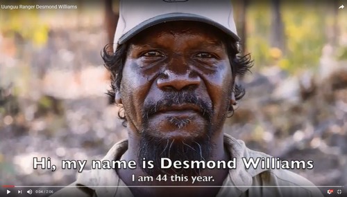
Talk again soon! Birgit Destination Kimberley, Destination Top End and Destination Red Centre have all the information you need to put together your dream trip. To sign up for this newsletter and receive the free Kimberley Pocket Guide go here. Feedback? Found some out of date info in one of my guides? Let me know via https://www.kimberleyaustralia.com/contact.html (c) 2005-2018, Birgit Bradtke. All rights reserved. |
| Back to Back Issues Page |