| Back to Back Issues Page |
 |
|
Kimberley and NT News: Severe cyclones in WA and NT, Gibb River Road open, Kalumburu Road to open March 26, 2019 |
26 March 2019, Issue #076 Please do not reply to this message. To unsubscribe or change your address please use the links at the bottom of this message. To contact me please use the contact page. To sign up for this newsletter and receive the free Kimberley Pocket Guide go here. In this issue:
Hi, Last weekend two severe tropical cyclones visited Australia, one hit WA and the other one the NT. Yet despite it being only late March, the Gibb River Road is open and the Kalumburu Road should open Wednesday. I also have a number of updates for you, so let's get into it.... 
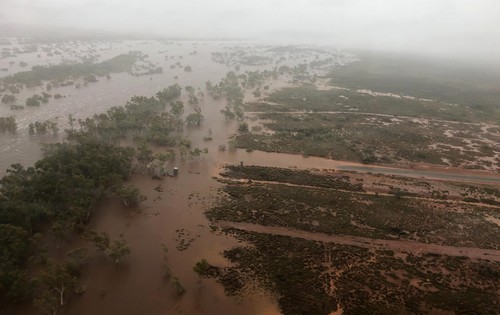
Severe Cyclones In The NT And WA We can pick up where the late wet season outlook from the last newsletter issue left off. It said that some weather models predicted a chance of monsoonal rains and possibly cyclones from mid March. And that is exactly what happened. The monsoonal trough moved south and reached Australia, and it had tropical lows embedded within it. Given the warm temperatures over Australia and in the surrounding oceans, it is not surprising that those lows developed into cyclones, two of them at the same time. Tropical Cyclone Trevor initially impacted the Cape York peninsula in Quueensland as a category 3 storm. It then moved over the Gulf of Carpentaria, intensified to a category 4 and eventually made landfall on the NT on Saturday morning. Trevor was a very powerful storm, on par with the devastating cyclone Tracy that flattened Darwin in 1974. At its peak, wind speeds in the centre reached 250 km/h. Luckily Trevor crossed the coast east of Borroloola and Port McArthur, so those towns were spared the most destructive winds. 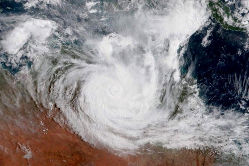
Cyclone Trevor on Saturday, 11 am.
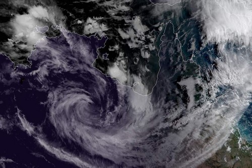
Trevor, now a tropical low, around midnight.
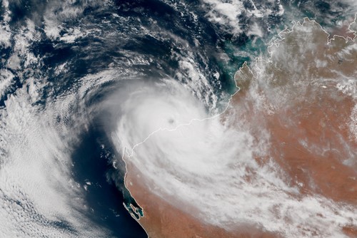
Cyclone Veronica, stalled off the Pilbara coast on Sunday morning.
Gibb River Road Open, Kalumburu Road To Open Wednesday Yes, the Gibb River Road is already open all the way and grading is about to start. In fact, it has been open since March 15, but nothing along it is open yet. Most gorges and properties will not open until May. Exceptions: El Questro will open April 1, Emma Gorge on April 17. Digger's Rest opens on April 18. So for most of the Gibb, right now all you could do is drive through and look at the landscapes to the left and right. If you want to do that, please be aware that the road is still very rough with quite a few washouts, and also that the roadhouses are still on wet season hours. And that the first tourist already got bogged in the Barnett River. So check with the roadhouses if you need anything, and do check recent rainfalls as even isolated showers can make parts of roads and tracks boggy and can let creeks and rivers rise. The Fairfield Leopold Downs Road is closed between Tunnel Creek and Windjana Gorge, and the parks are still closed anyway. The Kalumburu Road has held up well over the wet. It should get inspected by the shire as we speak and if all goes well it should open Wednesday (March 27). Honeymoon Bay, McGowans Sunset Beach and the Mission Campground at Kalumburu are open for tourists. Drysdale Station will be selling diesel and unleaded once the road is open but other tourist services (camping, accommodation, meals) will not open until May 1. Mitchell Falls will not open before April 8. Reader Dave has this to say about the Tanami Road: "The Tanami desert road from Alice Springs to the Granites is currently in the worst shape it has ever been. It is not suitable for any caravans, off road or otherwise. There are currently at least six triple road trains going in and out daily and they don't get through unscathed." (I received Dave's message on March 17 and published it on my What's New? page, as I sometimes do when important information reaches me between newsletters. So you may want to check that page before leaving for a trip to make sure you don't miss any such important updates.) More Updates In April last year, in newsletter #65, I told you that Wongalala Falls at Kalumburu had been opened for tourists for the first time ever, on a trial basis. Newsletter #66 also mentioned that signs had been installed around Kalumburu, including the Wongalala turn off. I have good news: It appears that the tourists visiting Wongalala in 2018 heeded the requests to treat the place with respect. Everybody looked after it, nobody left any litter. As a result Augie Unghango, the main traditional owner for the area, agreed to open the falls again to tourists this year. Hooray. One thing has changed though: The sign at the turn off to Wongalala has been removed. The traditional owners want to avoid having hordes of tourists going out there (possibly even without a tourist permit yet, as the turn off is located before you reach the township). If you want to head out to Wongalala, the campsite managers at Kalumburu can tell you what you need to know about it (you also find that info in Destination Kimberley) and they will tell you how to get there and what state the track is in. Naturally, if they see people leaving rubbish around the camp or behaving disrespectful towards the place in any way, well, then they won't tell them. Easy. And here is a video by the first tourists who made it to Wongalala last year without a guide. 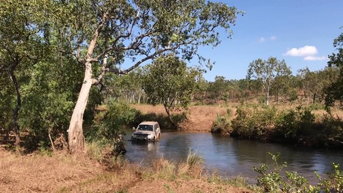
(Watch the video to find out why some may prefer to go with a guide.) This year's Gibb River Road Bike Challenge takes place from May 19 - 23. You may want to avoid the large number of bikes and support vehicles on the road and in the campgrounds, or you may want to get a chance to watch the spectacle. Either way, here are the dates: Sunday, May 19: Derby - Imintji Monday, May 20: Imintji - Mount Elizabeth Tuesday, May 21: Mount Elizabeth - Ellenbrae Wednesday, May 22: Ellenbrae - Home Valley Thursday, May 23: Home Valley - El Questro A new campgound is set to open at Baula-Wah community, or "Violet Valley". The community is located between Warmun and the turn off to the Bungles. It is 13km off the highway and the access track is only suitable for 4WD and offroad camper trailers. Violet Valley has 12 sites located along a ring road, all private and secluded in the bush. The campground will open some time in June/July. Once it does I think it will be a lovely option for people wanting to stop outside the Bungles but who aren't keen on a big, commercial caravan park. I will add more precise info, including how to get there, prices and contact details, to Destination Kimberley in the next days. Reader Feedback This email from Johan in Switzerland touches on several points that I have mentioned before in this newsletter and that I feel are worth repeating: "First and foremost, thank you very much for the two very informative books Destination Kimberley and Destination Top End. We have used them diligently in recent years. We are a couple of seniors who live in Switzerland and who have visited Australia for many years, usually 2-3 months per year. We are especially fond of the Kimberley and Gibb River Road. We have been through several times, and simply cannot get enough of the many beautiful gorges, as well as the landscape at all. We can see, as you have also noticed in your newsletters, that the Gibb River Road is becoming increasingly commercial, but yet there is a lot of nature to explore. Previously, we have used rental cars, but after a very unfortunate episode in 2017 with Australian 4WD Hire, we decided last year to buy our own Bush Camper, a large 4WD with high clearance, snorkel and radios, roof top tent and all accessories. We have our base near Kununurra where our car stands when not used. Last year we were in Cape York, another great destination. Later same year through the Gibb to Michell Falls, for the first, but definitely not the last time. We followed your description to Cape Leveque and camped at Middle Lagoon. We have visited Lake Argyle and taken the sunset tour a couple of times, but find the sunset tour from the Zebra Rock Mine much less commercial and absolutely as beautiful. From Lake Argyle, with Lake Argyles Adventures you can visit Roy's Retreat, an amazing experience. This year we are planning to spend most of the time at Destination Top End and in particular Kakadu park, we look forward to following your descriptions." For more information on Australian 4WD Hire see newsletter issue #73. The Zebra Rock Mine and Roy's Retreat are of course covered in Destination Kimberley. Well, and if you browse through the archived back issues from last season you will find many, many reader letters talking about the increase in tourist numbers and the resulting changes along the Gibb. Graham writes: "My wife and I and our 3 kids (aged 6, 9 and 11) did a 10 week journey from Melbourne up through Uluru to Kakadu, and then across to Broome on the Gibb River road last July to October, and your books were one of the highlights of our trip. We used your Red Centre and then Top End books, and then as we passed into WA we had a ceremonial move to your Kimberley book. Every day as we moved along our journey we would open up to the next page in your book and the whole family would listen as we read your words about our next destination, and then it felt like something was missing when we headed south from Broome through the Pilbara and West Coast and we didn't have you with us. Perhaps another book in the making for you?? Anyway, thanks so much, you really made our holiday and we quickly came to rely on your guides to help us source the best things we could do along the way. Hopefully we can do the whole trip again with your guides in the coming years, we loved it." Thanks so much for the glowing feedback, Graham! Well, Graham is not the first to suggest I add another volume to the Destination Guide series. Many of my readers travel from Perth to Darwin or vice versa. It is not official yet, but the trip planning service that I always so warmly recommend is also trialling an expansion down the west coast. And I have been dreaming about adding such a guide to the Destination guide series for quite a few years. The thing is, there is a reason why the Red Centre guide was not written by me but by Monica Coleman. She knows that part of the world a lot better than I do! Writing a Destination guide requires intimate knowledge of a region, knowledge that can only be acquired by spending many years there. It can't be gathered on just a research trip or two. The Pilbara and west coast? I know next to nothing about it. So, I won't be writing such a guide. The question is, will SOMEONE write it? Do you happen to know of someone who may have such a guide in them? Someone who knows the Pilbara and/or west coast like the back of their hand AND who has the motivation and ability to get that knowledge down on paper (or rather, a screen)? If you do, please send them my way and let's talk. I am not holding my breath by the way, but hey, it never hurts to ask, right? And that's it for today. One last reminder: Well over 120 people have already ordered the book 100 Things To See In The Kimberley, which I reviewed in the last newsletter. If you ordered, you should have already received your book or should receive it soon. Please let me know what you think about it! And that's really it. You should hear from me again soon, with more updates and info on what is happening with the weather and with everything else, as the Kimberley and Top End season slowly gets under way. Until then, happy planning! Birgit Destination Kimberley, Destination Top End and Destination Red Centre have all the information you need to put together your dream trip. To sign up for this newsletter and receive the free Kimberley Pocket Guide go here. Feedback? Found some out of date info in one of my guides? Let me know via https://www.kimberleyaustralia.com/contact.html (c) 2019, Birgit Bradtke. All rights reserved. |
| Back to Back Issues Page |