Lake Argyle, Australia
Pictures and Visitor Information
Lake Argyle in Western Australia will likely be your first stop in the Kimberley if you are travelling from Darwin/Katherine or your last stop coming from Broome.
The huge man made lake is near the border between Western Australia/the Kimberley and the Northern Territory. It makes for a good stopover on the way to Kununurra.
Alternatively you could always visit in a day trip from Kununurra. It's not far and it's a beautiful drive. I drag all my visitors up there...

Lake Argyle, Western Australia, In Pictures

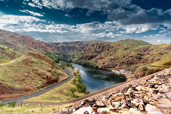
Above is a view over a very small part of the lake from one of the lookouts.
To appreciate the dimensions of Lake Argyle you need to take a scenic flight. Any photos taken while driving or walking will only show a tiny part of it. Even the cruises don't access all that much of it.
Lake Argyle covers an area 18 times the size of Sydney harbour, 1000 km2. At full flood level that area increases to 2100 km2!
 Picture courtesy of Aviair
The main Ord Dam, which holds back these huge amounts of water, is surprisingly small.
In the photo below you see the dam and above it a small bay with some boats anchored in it. The Lake Argyle Resort is not in the picture, it is up on the hills to the left of the little bay.
Above the land mass in the top half of the photo you see the waters of Pannikin Bay.
 Picture courtesy of Aviair
Here is a map of (very) roughly the area you see in the picture. Zoom out and you may start to get an appreciation of just how large Lake Argyle really is.
By the way, don't confuse the main Ord Dam holding back Lake Arglye with the Diversion Dam west of Kununurra. The Diversion Dam also dams the Ord River and holds back the much smaller Lake Kununurra. The main highway (Great Northern Highway) crosses the Diversion Dam.
Here is a photo of it:
 Picture courtesy of Aviair
Unlike the concrete and steel structure of the Diversion Dam with its hydraulic gates, the main Ord Dam up at Lake Arglye is an earth filled dam with an impervious clay core. A road crosses the dam and then leads down and ends at a well maintained grassy picnic area at the bottom of it.

The next photo was taken from the top of the dam. It shows the Ord River below the Ord Dam, disappearing into the direction of Carlton Gorge.

You can't see the picnic area. It's under the trees on the left of the river. But what you can see really well here are the hills I mentioned in the beginning. they belong to the Carr Boyd Range. This is the kind of country you are driving through to get to the lake. Red, red hills, narrow valleys, and the occasional glimpse of the lake as you get closer.
The photo below was taken from slightly higher up. It's from my readers Mike and Amanda and is much better than mine.
 © Photo by readers Mike & Amanda from Red Dirt Australia
Another and even better option to see these hills is to take a cruise on the Ord River between Kununurra and Lake Argyle. (You can do so in either direction and combine it with a bus transfer.)
And here we are in the same spot, on the dam, but looking into the other direction, over the lake:

The bottom of the dam was already in the shadows, but the hills on the other side are still lit up by the evening sun.
One of the unusual features of the Ord Dam is the fact that its overflow, called the Spillway, is not situated at the dam itself but at the northern end of Pannikin Bay. From there the water makes its way along Spillway Creek, through the Carr Boyd Range, back into the Ord River.

The above photo was taken on the way to the lake, standing under the bridge that goes over the creek. It's the end of the dry season and there isn't much water left.
The picture also gives you a glimpse of the hills that make this drive so interesting. This is a country of mostly flat and straight roads, which makes the drive to the lake all the more remarkable.
I really love the drive itself and try to catch the best light for that part of the trip. As a result I am always a bit late getting to the lake itself ...

The last of the sunset over the lake.
If this is your first visit to Lake Argyle and you only go for a day then I recommend you go very early, have a good look around, visit the museum (see below), catch one of the cruises, and enjoy the late afternoon sun in the hills of the Carr Boyd Range on the drive back.
 Picture courtesy of Aviair
Lake Argyle Visitor Information
Getting there:
The turn off to Lake Argyle is 35 km east of Kununurra and 7 km west of the NT/WA border check point. From there it is another 35 km, an exceptionally scenic drive through the hills of the Carr Boyd Ranges.
Lookout Points:
The signposted Spillway Lookout can be found on your left, a few kilometres after you cross the bridge over Spillway Creek, on your drive towards the lake. Pannikin Bay Lookout is also on your left, also shortly before you get to the Argyle village. It can also be reached on foot via a short walk from the Arglye Resort.
Several more lookouts, all well signposted, are situated between the Argyle Resort and the main dam. Of course the dam itself offers great views, too.
But the best views you have to earn, they can only be reached on foot via the Ord River Gorge Walk Trail and the longer St. Georges Terrace & The Bluff trail.
Boating, Swimming, Picnic Area:
Before you get to the dam a track to the left takes you down to the boat ramp. You can also access the lake for a swim from here, unfortunately there is little shade to be found. (A popular alternative for swimming is the famous Infinity Pool at the Argyle Resort, see below.)
To get to the picnic area just continue following the the road across the dam to the end.
Tours:
Argyle Cruises offer morning, sunset and full afternoon cruises on the lake.
Triple J Tours do cruises on the Ord River from the lake to Kununurra or back.
Check Helispirit for scenic helicopter flights, Aviair for fixed wing flights from Kununurra.
Accommodation:
Resort Lake Argyle. Everything you could ask for. (I.e. huge, well appointed caravan park with powered and unpowered sites, different size cabins and villas, kiosk, restaurant, general store, fuel, booking desk...)
The popular Infinity Pool is free to use for guests, day visitors are welcome and pay a fee.
Argyle Downs Homestead Museum:
In 1971 the famed original homestead of early Kimberley pioneer Patsy Durack was dismantled and moved from its original site to prevent it from being flooded by the dam. It has been reconstructed as a museum about those early pioneering days. You can reach it on foot from Argyle Resort via a scenic walking trail or drive the 2 km.
Read more about the Kununurra region.
See more Kimberley pictures.
Travelling to the Kimberley?
The FREE Kimberley Pocket Guide
A great introduction to travel in the Kimberley region and along the Gibb. This free resource will answer all the questions you might have in the early stages of planning a trip.
Destination Kimberley
The full Kimberley travel guide shows you how to make the most of your adventure at Australia's last frontier. Destination Kimberley includes the most detailed and most current guide to the Gibb River Road available anywhere. Also called "The Bible" by its readers.
Travelling to the Northern Territory?
Destination Top End offers the same comprehensive, detailed insider information for the tropical regions of the Northern Territory. Be the best informed traveller in the Kakadu, Litchfield and Katherine Gorge national parks and beyond!
A must have if you travel to or from Darwin.
NEW! Destination Red Centre is the latest addition in this popular series. Monica Coleman takes you through Australia's red Outback heart, offering all the detail and insider tips that you have come to know and love about our guides. With special emphasis on Aboriginal communities and culture.
A must have if you travel to or from Alice Springs/Uluru.
Thanks for visiting! Have you
requested your free guide book yet?
I offer a free guide to the Kimberley plus a free, very popular newsletter.
If you plan to visit the Kimberley, you can't afford to miss either.
Don't believe me? Learn more about the free pocket guide here and see the newsletter archives here.
Read more about the Kununurra region.
See more Kimberley pictures.
SUBSCRIBE ABOVE TO RECEIVE YOUR FREE KIMBERLEY POCKET GUIDE!
DESTINATION KIMBERLEY, ALSO KNOWN AS "THE BIBLE".
DESTINATION TOP END, YOU NEED THIS IF YOU ARE TRAVELLING TO OR FROM DARWIN
DESTINATION RED CENTRE, THE LATEST ADDITION TO THIS POPULAR SERIES, COVERS THE OUTBACK AROUND ALICE SPRINGS AND ULURU